Tourist circuits in Gualjaina See map
Gualjaina, is located northwest of the province of Chubut, near the city of Esquel and pass for visitors to El Bolsón.
Situated on the Costa del Lepá Valley and Gualjaina Valley, in the Lepá riverside. During your stay tourist circuits can be made to view the rich archaeological, paleontological, historical and cultural sites. The circuits are made in all cases accompanied by local guides.
Some of the circuits most done is a visit to Piedra Parada Valley, a Nature Reserve between the towns of Gualjaina west and east Paso del Sapo.
Natural Reserve of Piedra Parada Valley circuit
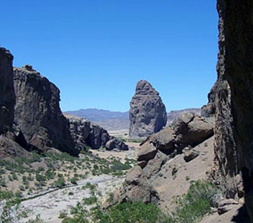 Through the circuit before reaching Piedra Parada.
The standing stone is a rock formation of volcanic origin over 250 meters high and 100 meters wide. The volcano that gave birth became extinct thousands of years ago, but it used to eject lava within a radius of more than 30 kilometers, that's what caused these formations that we see on the surface in these times. The same volcanic legacy has left vast canyons, mountains and even caves.
This special place was declared a nature reserve, because it is also necessary to preserve the paintings, petrified logs and objects of archeological value left by native peoples.
Starting from Gualjaina, the trip to Piedra Parada lasts 8 hours. The meeting point of departure is the city of Gualjaina, the tour includes lunch and snack.
You have to take Provincial Route No. 12 to start the tour just 3 km away from the Ventana hill and left of the road the Cross and the Virgin. Then pass around 5 km to the diversion route to Cushamen, distant 70 km Provincial Route 33, and should be continued for the No. 12 to Paso del Sapo.
After that you get to the catwalk of "El Mirador", where is the rivers Gualjaina and Chubut confluence. Cross the bridge over the Gualjaina river and within walking distance on the right of the road is access to School No. 29 "Costa del Gualjaina". The rest of the way is surrounded by the Gauljainamountains and Chubut river.
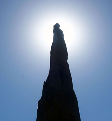 Piedra de la Virgen: rock formation with the Virgin Mary Shape.
Continue the path until you reach the monumental Piedra Parada. There you can go climbing, a physical activity and leisure highly reacreativa with a high margin of safety. Access to these areas for recreation or climbing should be done with permission sought from the authorities of the municipality of Gualjaina.
There are places previously established for camp, which can be found in Tourism Office, which coordinates the activities that can be develop in the region.
The second part of the circuit includes a visit to Canyon of the Vulture and the Stone Bridge.
Canyon of the Vulture
The canyon of the vulture is a trail that locals primitive used to cross to the Paraje El Mirador bound Ing Jacobacci in carts pulled by mules.
The circuit of vultures is on foot and lasts about 90 minutes. All the trail is surrounded by a small stream.
After several meters on the left side, you arrive at an excavation conducted in 1979 by a group of geologists who established among other findings, the confirmation of existence of life of native peoples with an age of 5070 years in this area.
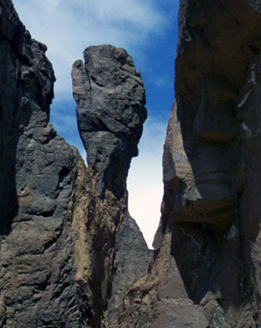 The Box Glove.
Continuing the journey, there are rock formations that form figures, among them there is one very similar to the image of the Virgin Mary and the other like a box glove. There are other stones that have been naturally carved called the Virgin of Vulture, the Elf of Vulture and Face of the Indian.
Along the way there are forwards with engravings, paintings and drawings, marine fossils, petrified logs and added to this great reservoir of the origin of the planet, you can also enjoy activities such as mountain biking, horseback riding, hiking, fishing, climbing to interest of those who come to the area.
Circuit Large Canyon
This tour is only with local guide. Departure is from Gualjaina and has approximately 6 hours. The first objective of this trip is going to meet the Alonqueo family belonging to the Mapuche community.
You take the Provincial Route No. 12 and Provincial Route No. 33, reaching the only Ruca (house) located on the end of the canyon. The Alonqueo family transmitted their knowledge and culture to visitors, offering alternatives like walking through a craft using original techniques, trekking to Mount Bandera and share a meal or snack in this small tourist cattle place.
Walk
This alternative of climbing the Bandera hill is part of a particular legend, from where panoramic views can be obtained of Fofo-Cahuel (Crazy Horse), the Coast of Gualjaina and Gualjaina Valley.
La Ventana hill circuit
The departure is from the Plaza San Martín in Gualjaina and lasts approximately 3 hours, biking or horseback riding.
Leaving the square, cross the bridge over the Lepá river and left Provincial Route No. 14, up to the house owned by Dionisio Lara. This stretch of the route on the right side of the road there is a field of riders.
After going a few kilometers the road forks to the left and the from the path that continues you can observe a step capable of fording the river with vehicles.
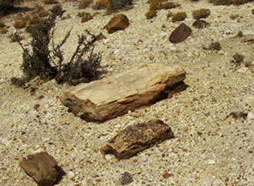 You can find pretified logs.
Taking up the road reaches the walkway of Gualjaina river, which was built in the mid-70's - which immediately crosses is an old adobe building. Continuing the drive along the trail that is in the place, and a few meters there is a mountain fold with very particular characteristics, known as La Ventana hill, considered unique vantage point to see the valley and the town of Gualjaina. A trail allows you to scale the hill, where we will discover the shape as the one that its like a window, a stone cave.
On the left is the Gualjaina river a few meters away is the confluence of the rivers Lepá and Gualjaina. In this place the way have a fork and the path leading to the establishment of the Ovando family (the road continues to the right toward the mountains). Already in the Ovabdo field there is a "boca toma" built there by the family itself, from where an irrigation canal carries water to the main house and the countryside. When crossing, pass the house and 300 m from the historical plaque that commemorates the passage of the Welsh. Here the story says John Daniel Evans went on his horse "El Malacara," which his skill saved the life of the rider being ambushed in Las Plumas area. The plaque reads: "From this place we found and chased by the Lancers Foyel the 27/02/1884. Pursuit which my three comrades were killed in the valley of the martyrs on 04.03.1884". In memory of John D. Evans, his son Milton Evans - 27/02/1987.
Source and photos of Gualjaina municipality, email: munigualjaina@yahoo.com.ar - Telephone: (02945) 479106
Viajes por la Patagonia

© Patagonia.com.ar 2025 | Todos los derechos reservados.