Perito Moreno Glacier, what you need to know See map
Every year the Perito Moreno glacier generate expectations in the world relative to its breakup. Some data on its characteristics and its history will help us understand this phenomenon.
Los Glaciares National Park was created in 1937 for the preservation of the glaciers and was declared a World Heritage Site by UNESCO to preserve its flora and fauna in danger of extinction.
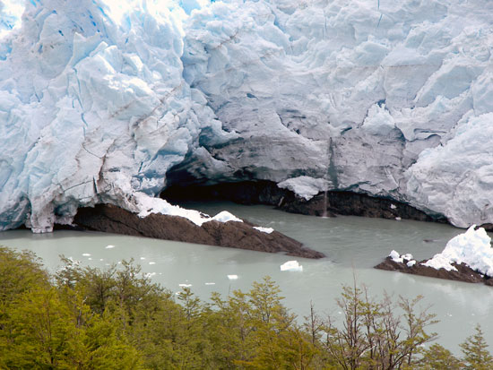 Part of the glacier image. Photo courtesy of Jan Zkelj - Sec. of Tourism
Glaciers play an important role in our day, occupy 10% of land surface and account for 90% of the world's freshwater. And with the air and water flow that create, contribute to balance the Earth's climate, which without them would be suffocating.
There are many myths and comments on the Perito Moreno glacier and its behavior that every year surprise and invites tourists from around the world. But to begin to understand, we must ask:
What is a glacier?
A glacier is often compared to a river of ice because it have tributaries, erosive capacity and greater speed in the middle of the channel than at the edges. But the movement of ice, like all bodies, follow the laws of gravity and very specific behaviors that have little in common with the water.
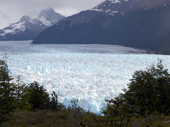
 Los Glaciares National Park. Photo courtesy R. Garcia
The ice of glaciers is the result of compression of the snow effect of its own weight. For the formation of a glacier takes large snowfall and the average annual temperature for retaining snow. The snow is compressed and accumulates in layers that are compacted and by the weight it form the ice.
The time required for the formation of ice from the snow varies greatly from one glacier to another depending on two factors: the snowfall and temperature and can range from a dozen years like in the alpine glaciers or glaciers from Patagonia or several hundreds of years like in Antarctica.
The important thing to know about the glacier is that is not only a mass of ice, but above all, a mass of moving ice. And as every body in motion, the ice is influenced by gravity. Because of this similarity with water the glaciers are compare to rivers which, if it is not entirely false, in light of recent studies also doesnt' seem to be quite true.
A glacier is only a glacier if it moves and to start to move the ice needs a certain thickness of about 20 meters. From here, three factors will condition the forward speed of a glacier: the thickness, slope and ice temperature.
The glaciers covered in the last great ice age about 18,000 years ago one third of the landmass, which was 3 times its present size. Sea level then dropped 120 meters, with the result that large areas now covered by sea water, were then dry land. In southern Patagonia, the first ice age that left clear footprints was 3.5 million years ago and at that time, the ice extended at least 60 km east of the Andes today.
About the Name
The glaciers from Patagonia are named after Perito Moreno since 1899. But the story tells that Perito Moreno has never seen the glacier, despite having been very close his exploration in 1876 because the glaciers are never mention in his report.
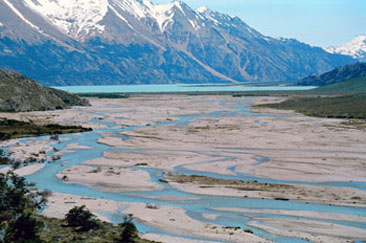 Río Lácteo valley. Photo cuortesy of Sec of Tourism
In 1879, John Thomas Rodgers, English captain of the Chilean Army, would be the first explorer to mention the glacier and give it a name: he called glacier Francisco Vidal Gormaz in honor of the Director of the Navy Hydrographic Office in Chile. Years late Hauthal attached to the Argentinian Boundary Commission would call it Bismarck in honor of Prussian Chancellor. That name that still appears on some german and chilean maps. But Lieutenant Iglesias in a studio appointed by the Argentine Hydrographic Institute definitely named the glacier Perito Moreno.
The rupture
The breaking of the Perito Moreno Glacier is one of the most impressive natural phenomena that have been seen in recent times. The various breakdowns show that there is a cyclic parameter in the Perito Moreno:
- In 1900, the front of the glacier was 750 meters from the coast of the Peninsula of Magallanes. 350 meters in 1908. 100 meters in 1914 and in 1917 touched for the first time the Magallanes Peninsula going back a few weeks later without serious consequences.
- In 1926 geologist E. Feruglio says that the canal between the glacier and the edge of the Buenos Aires hill was wide enough to allow passing a small boat. Two years later, the width of the canal reached about 150 meters.
- In the summer of 1939-40 was the first time the phenomenon took place. The breakdown of Perito Moreno Glacier's front face was in February 1940.
- In March 1942 his second break occurs. The difference in water level reached 19 meters causing major flooding on the shores of Brazo Rico.
- After this break, and for ten years, the glacier tongue touched the coast several times to produce successive breaks (1947 and 1949).
- In the years 1949 and 1950 were recorded in the area much higher rainfall than normal. The glacial advance recorded this increase and almost 13 meters apart the pressure pops the ice shelf and in March 1952 rupture occurs.
- In September of that year, the glacier was closed again and in March 1953 there was a new break because waters reached a height of 14.5 meters.
- Three years later, in early 1956 a new rupture occurs. The following closures until 1966, didn't seem to have caused major flooding.
- Since 1970 the glacier had several breaks in a cycle of 2 to 4 years (1970, 1972, 1975, 1977, 1980, 1984 and 1988). But from there we had to wait 16 years until the next break in 2004, and the next were in 2006 and 2008.
It is often said that the rupture of Moreno is a phenomenon that repeats cyclically every 3 or 4 years. As discussed above, this only occurred regularly in recent years. Just look at the list of breaks to see how wrong is that idea.
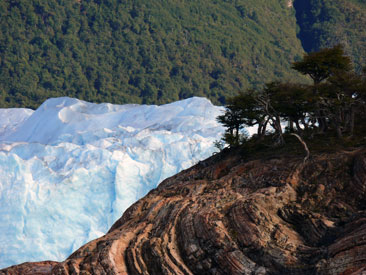
 In this image you can see the flora around the glaciers. Photo courtesy Jan Zarekj
Technical data of the Perito Moreno Glacier
It covers an area of 6,000 km2, covering part of the Continental Ice and all the glaciers that from them descend to the eastern side.
- Geographical Location: 50 º 29 'South and 73 º 03' west
- Speed: 2.2 meters per day in the center and 0.35 meters per day at the edges. The speed was measured at 5 km from the front and with an interval of one day in 1990.
- Length: 30 km.
- Surface: 257 km2.
- Thickness: Studies in the lateral moraines and in the forest that flanks the glacier have specialists assume that, also unlike the rest of the glaciers in the area, has not changed Perito Moreno glacier mass substantially in the last 500 / 1000 years.
- Front Width: arround 4 km
- Line of balance: around 1,150 meters above sea level
- State of it fronthead: steady since about 1917. Although since then the glacier has been oscillating in minor advances and retreats, we can say that in general, retains the status it had at that time. When we say that a glacier advances or retreats, we are referring only to the front line, because, as we saw earlier in all glaciers, the ice is constantly moving forward, because of sliding or deformation.
- Height of frontage above the lake level: from 50 to 70 meters.
- Maximum height of the basin: Pietrobelli hill (2,950 meters above sea level).
- Depth of Lake: only once measured the depth of the Brazo Rico along the glacier founding a maximum of 137 meters.
- Height of the lake above sea level: 185 meters.
- Lake water temperature: 4 to 6 degrees.
- Color of water: the characteristic color of the lake, commonly known as "glacial milk", is due to mineral particles suspended in the water from the glacier abrasion against its bedrock and rocks together, which by microscopic size fail to settle to the bottom.
Source and photos: Secretaría de Turísmo de la Provincia de Santa Cruz. www.santacruzpatagonia.gob.ar
Bibliography: Alonso, Miguel Angel (1993) "Manual de Lago Argentino y Glaciar Perito Moreno". Talleres Gráficos de Editorial Acme, S. A. C. I. Buenos Aires
Viajes por la Patagonia

Related Articles
© Patagonia.com.ar 2026 | Todos los derechos reservados.